


LA VALLEE DE L'YON n°9 sentiers Chamina

cath310
User

Length
16.7 km

Max alt
68 m

Uphill gradient
222 m
Km-Effort
19.7 km

Min alt
8 m

Downhill gradient
222 m
Boucle
Yes
Creation date :
2021-10-16 20:13:29.366
Updated on :
2021-10-16 20:23:20.583
4h28
Difficulty : Easy
4h28
Difficulty : Very difficult
--
Difficulty : Very easy

FREE GPS app for hiking
 SityTrail
IGN / Geographical institutes
SityTrail Plus
The world is yours!
About
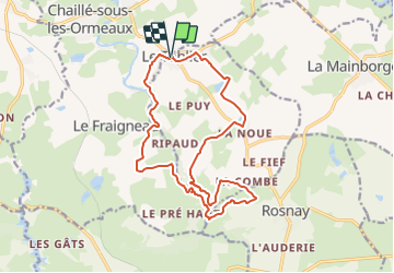
Trail On foot of 16.7 km to be discovered at Pays de la Loire, Vendée, Le Tablier. This trail is proposed by cath310.
Description
D/R parking de l'Eglise du TABLIER 85
balisage : jaune au départ jusqu'à la Grassonnière
jaune-rouge : à partir de la passerelle filature en ruine jusqu'au R
Positioning
Country:
France
Region :
Pays de la Loire
Department/Province :
Vendée
Municipality :
Le Tablier
Location:
Unknown
Start:(Dec)
Start:(UTM)
626959 ; 5159147 (30T) N.
Comments